Three U.S. Hurricane Hot Spots Predicted for 2015: El Niño Likely Fading by Mid-August

Ocala, Florida (PRWEB) April 17, 2015 -- Global Weather Oscillations Inc. (GWO), a leading hurricane cycle prediction company, says that despite the presence of an El Niño, the 2015 Atlantic hurricane season will be the most dangerous in at least 3 years, and there will likely be 3 hurricane or strong tropical storm landfalls along the United States coastal areas. In addition; the next 3 seasons will be the most dangerous in 10 years.
CEO David Dilley says GWO (http://www.GlobalWeatherOscillations.com) has issued the most accurate predictions of any organization 6 years running, and is the only organization that uses Climate Pulse Technology to produce accurate pre-season hurricane zone predictions along the United States coastline. GWO was the only organization to predict the correct number of hurricanes in 2014 and that an El Niño would not form.
GWO is predicting the El Niño to fade during July into early August; much like the 2006 El Niño did. The 2015 hurricane season will likely begin slowly with a few tropical storms and possibly a hurricane, and then become quite active from about mid-August into October. GWO is predicting 10 named storms, 6 hurricanes, 2 major hurricanes and 3 United States “Hot Spot” areas for landfalls.
Although 3 landfalls may seem high when only 10 named storms are expected, it is not uncommon. The 2006 season was also influenced by an El Niño until August, and it had 9 named storms, with 3 of them making landfalls along the United States coast. Two of them were very strong tropical storms of near hurricane strength.
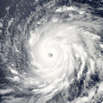
GWO is urging people not to take the 2015 season lightly. Ocean water temperatures are running warmer than average in the Western Atlantic and Gulf of Mexico, and any storms that form near the United States have the potential to be stronger than those seen during the 2006 El Niño season.
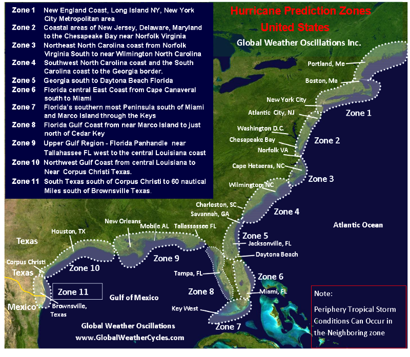
When predicting a hurricane season the most important prediction is not how many named storms there will be, but instead; how many landfalls there will be, and where will they occur. GWO is predicting three “Hot Spot” landfall areas along the United States coastline that are all at high risk for hurricane activity this year, with 1 major hurricane landfall possible. And we should remember the 1992 hurricane season that also had an El Niño. Only 6 named storms and 2 hurricanes occurred in 1992, but one was “Andrew” a major Category 5 Hurricane that devastated parts of South Florida, and then made a second landfall as a major Category 3 hurricane in Louisiana. Mr. Dilley also says that despite this year’s El Niño, the next few years will enter a natural “Climate Pulse Enhancement Cycle” that will be favorable for more active and intense hurricane seasons for the United States.
When GWO predicts a high probability for hurricane conditions within one of their 11 prediction zones, it is red-flagged as a hurricane or tropical storm “Hot Spot.” GWO’s hot spot predictions for the United States have been nearly 87 percent accurate since 2006. GWO is the only organization that predicts hurricane conditions for specific zones, and for up to 4 years in advance. Detailed predictions for the 11 hurricane zones can be obtained by going to (http://www.GlobalWeatherOscillations.com).
GWO issues predictions based on its “patent pending” Climate Pulse Technology developed by Mr. Dilley. GWO currently has 11 United States prediction zones from New England to Texas, and the Philippine Islands in the western Pacific, and also issues accurate predictions for El Niño events and other climate cycles.
GWO is the only organization to predict the correct number of hurricanes in 2014 and that an El Niño would not form. GWO was also the only organization to predict the very weak 2013 hurricane season, “Hot Spot” zone predictions of Hurricane Ike (2008), Irene (2011), and Sandy (2012). The prediction of Sandy, a high-impact hybrid storm was made 3 years in advance, and Irene 2 years in advance.
What makes GWO a standout from other organizations is their commitment to research and development of GWO’s “patent pending” Climate Pulse Technology (CPT) that incorporates natural mechanisms that control the rhythm of weather and climate cycles. Research over the past 30 years has found that each of the Atlantic and Gulf coastal zones have varying weather cycles, and within each cycle, there exists smaller weather cycles which make each zone unique. Once all of the cycles are discovered, Dilley then uses the Climate Pulse Technology to accurately assess the intensity of a future hurricane season, and the probability risk for hurricane or tropical storm conditions within a prediction zone for that year.
GWO Webinars, detailed hurricane zone predictions, past hurricane season verification, graphics, and the “free” climate change e-book “Earth’s Natural Climate Pulse,” authored by David Dilley can be acquired through the GWO web site http://www.GlobalWeatherOscillations.com.
In addition, an interactive electronic subscription to the GWO’s hurricane predictions can also be acquired through GWO’s working partner, XtremeGIS http://www.xtremegis.com the risk management division of Wall Street Network (WSN) http://www.wsn.net.
David Dilley, Global Weather Oscillations Inc., http://www.GlobalWeatherOscillations.com, +1 (352) 732-8170, [email protected]

Share this article