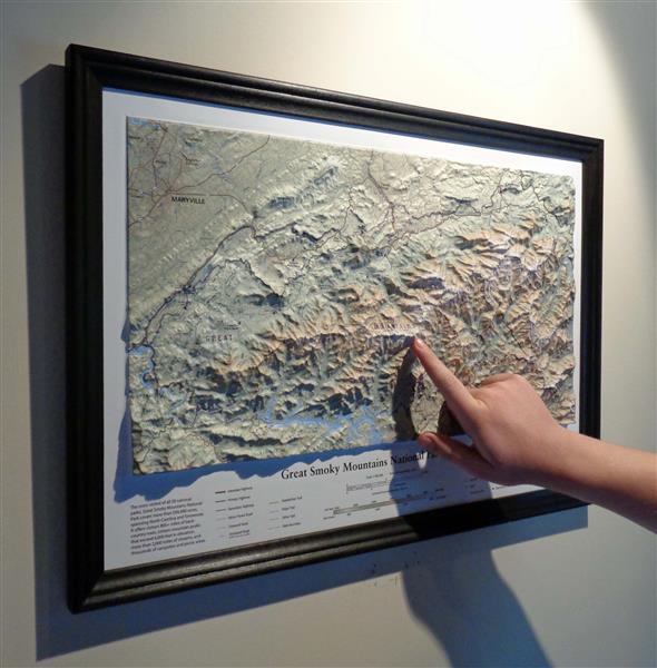
Great Smoky Mountains National Park in Miniature: SummitMaps Recreates 500,000 acres in 20”

Martinsburg, WV (PRWEB) May 05, 2015 -- Summit Terragraphics (SummitMaps.com), creators of raised relief maps, recently announced the release of a detailed 3D trail map of Great Smoky Mountains National Park.
As with their other maps, Summit uses a precision thermoform molding process to realistically reproduce the park’s rugged terrain in miniature (at at scale of 1:180,000). A subtle elevation color ramp image enhances changes in elevation while detailed annotations identify geologic features, trails (including the Appalachian Trail), shelters, campsites, roads and ranger stations, as well as rivers, streams, and lakes.
Great Smoky Mountains National Park, the most visited of all 58 national parks, covers more than 500,000 acres spanning North Carolina and Tennessee. It offers visitors 800+ miles of backcountry trails, sixteen mountain peaks that exceed 6,000 feet in elevation, more than 2,000 miles of streams, and thousands of campsites and picnic areas.
The new map is available, framed or unframed, online at SummitMaps.com and at select retailers, including National Park gift shops. The retail price for the unframed map is $19.95; framed maps range from $59.95 to $64.95 depending on the frame choice.
For additional information or higher resolution photos, contact Michael Higgins.
ABOUT SUMMIT TERRAGRAPHICS
Summit Terragraphics (SummitMaps.com) was established in 2007 with the goal of redesigning traditional raised-relief maps for greater precision and image resolution, taking advantage of the latest digital technology and a proprietary tooling process. The result has been the creation of attractive and highly accurate maps for home, business, and government use.
Michael Higgins, Summit Terragraphics, http://www.summitmaps.com, +1 304-274-0978, [email protected]


Share this article