Dangerous 2017 Atlantic Hurricane Season Predicted - GWO
Ocala, FL (PRWEB) February 01, 2017 -- Global Weather Oscillations (GWO]) says the 2017 Atlantic hurricane season will be stronger than last year - with the potential for 6 named storms making United States landfalls. It will also be the most dangerous since the 2005 season that saw 5 hurricane landfalls and 2 tropical storms
GWO has issued the most accurate preseason predictions of any organization the past 8 years, including last years’ prediction that the “Atlantic Basin” (which includes the Caribbean Sea and Gulf of Mexico) - would enter a Climate Pulse Hurricane Enhancement Cycle in 2016.
David Dilley, Senior Meteorologist for Global Weather Oscillations (GWO) - correctly predicted 8 months in advance that GWO’s prediction zones for the Florida Panhandle and Florida’s East Coast northward to North Carolina - would experience hurricane and/or strong tropical storm conditions in 2016, with multiple strikes likely (see GWO’s 2016 hot-spot predictions graphic).
As it turned out – 5 named storms made United States landfalls with Hurricane Hermine making landfall on the Florida Panhandle in the Eastern Upper Gulf (see Hot Spots graphic). But more importantly was Hurricane Mathew – a major hurricane that moved north across Haiti and the Western Bahama’s - then hugged the coastal areas from Florida to North Carolina. Unfortunately - 1,739 people died from hurricanes in 2016, most of which were from Hurricane Matthew in the Caribbean. The last time the death toll was that high was in 2005 when nearly 4,000 people were killed by hurricanes. In addition – it was the second costliest in eleven years with a little more than $11 billion in damages.
The official hurricane season begins on June 1 and ends December 1. The Atlantic Basin on average has 12 named storms, 6 hurricanes and 2.7 major hurricanes. As predicted by GWO, the 2016 hurricane season was more dangerous and costlier than average. The official season (minus Hurricane Alex in January) - had 14 named storms, 6 hurricanes and 3 major hurricanes – and the United States experienced much above normal activity with 5 out of the 14 named storms making landfall in GWO’s predicted Hot Spots, 2 of which were hurricanes (Mathew and Hermine).
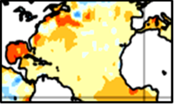
2017 Prediction - GWO’s Climate Pulse Hurricane Model indicates that 2017 will once again be influenced by a Climate Pulse Hurricane Enhancement Cycle - with very conducive conditions for hurricane development due to the lack of an El Niño, or La Niña conditions. In addition – ocean water temperatures continue to run warmer than normal across most of the Atlantic Basin (red and orange in the graphic), and especially in the Caribbean region and the Atlantic near the United States. This warmer ocean water will be conducive for tropical storms and/or hurricanes forming and/or strengthening close to the United States. Mr. Dilley also expects the Bermuda-Azores High Pressure Center will be weaker this summer – thus allowing more named storms to maintain strength - or strengthen as they move from east to west across the Atlantic toward the United States.
Mr. Dilley says the upcoming 2017 hurricane season will be stronger than last year, and it will be the most dangerous and costliest in 12 years for the United States. It will have 16 named storms (14 last year), 8 hurricanes (6 last year), and 4 major hurricanes (3 last year). In addition – the United States will have the potential for 6 named storms making landfall – the most since the 2005 season that saw 5 hurricanes and 2 tropical storms make landfall. GWO also expects 3 out of the 6 landfalls will be hurricanes – with 1 or 2 having the potential for being a major impact hurricane. And there will some different hot spots in 2017. More information is available through GWO’s free hurricane webinars and their detailed hurricane zone predictions at GlobalWeatherOscillations.com, or GlobalWeatherCycles.com.
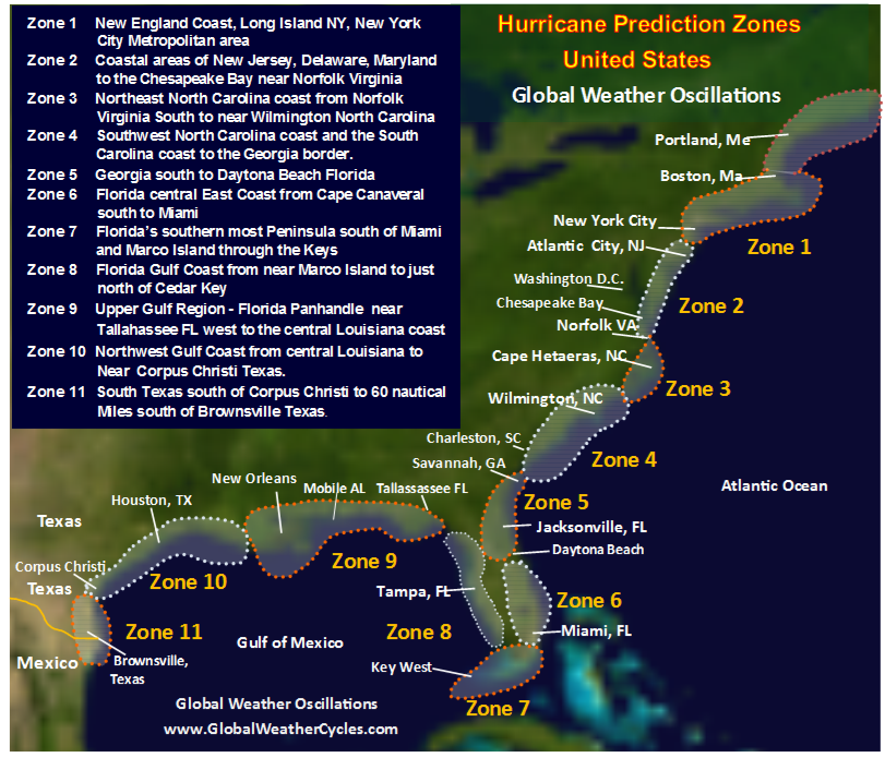
GWO is the only organization that issues detailed predictions two years into the future for 11 United States prediction zones stretching from New England to Texas. GWO’s hot spot zone predictions for the United States have been nearly 87 percent accurate since 2006 - with GWO correctly predicting 1 to 3 years in advance - the occurrences of Hurricane Ike (2008), Irene (2011), Sandy (2012), Mathew and Hermine (2016). Detailed zone and hot spot predictions for the 2017 and 2018 hurricane seasons can be obtained through GlobalWeatherOscillations.com, or GlobalWeatherCycles.com .
What makes GWO standout from other organizations is their commitment to research and development of GWO’s “Climate Pulse Technology” (CPT). The CPT prediction model incorporates natural mechanisms that control the rhythm of weather and climate cycles, which in-turn control future hurricane paths and landfall cycles. Research over the past 35 years has found that each of the Atlantic and Gulf coastal zones have different hurricane landfall cycles, and within each cycle, there exists smaller cycles which make each zone unique. When GWO predicts that hurricane conditions are likely, the zone is red-flagged as a hurricane or tropical storm “Hot Spot” for that year.
GWO and Senior Meteorologist/Climatologist David Dilley are leading experts on climate cycles and climate change - a “free” climate change e-book “Earth’s Natural Climate Pulse” (authored by Mr. Dilley) can be acquired through the Global Weather Oscillations web site.
David Dilley, GlobalWeatherOscillations.com, http://www.GlobalWeatherOscillations.com, +1 (352) 732-8170, [email protected]


Share this article