Quantum Spatial to Highlight LiDAR-based Vegetation Management at Western Energy Institute Operations Conference

PORTLAND, Ore. (PRWEB) April 23, 2019 -- Quantum Spatial, Inc. (QSI), the nation’s largest independent geospatial data firm, announced today that Program Manager Greg Denton will discuss how LiDAR-based remote sensing is helping utilities proactively address vegetation management challenges in a presentation at the Western Energy Institute (WEI) Operations Conference, taking place April 23-26 in Vancouver, British Columbia.
“Vegetation management has long been a labor-intensive and reactive process for electric utilities, which have relied on boots-on-the-ground, cycle-based programs as part of their effort to reduce risk along the transmission right-of-way,” said Denton. “We look forward to showcasing QSI’s novel application of remote sensing technology and advanced analytics that enables electric utilities to effectively mitigate the threat of dead and dying trees, and take proactive action to maintain the integrity of their infrastructure.”
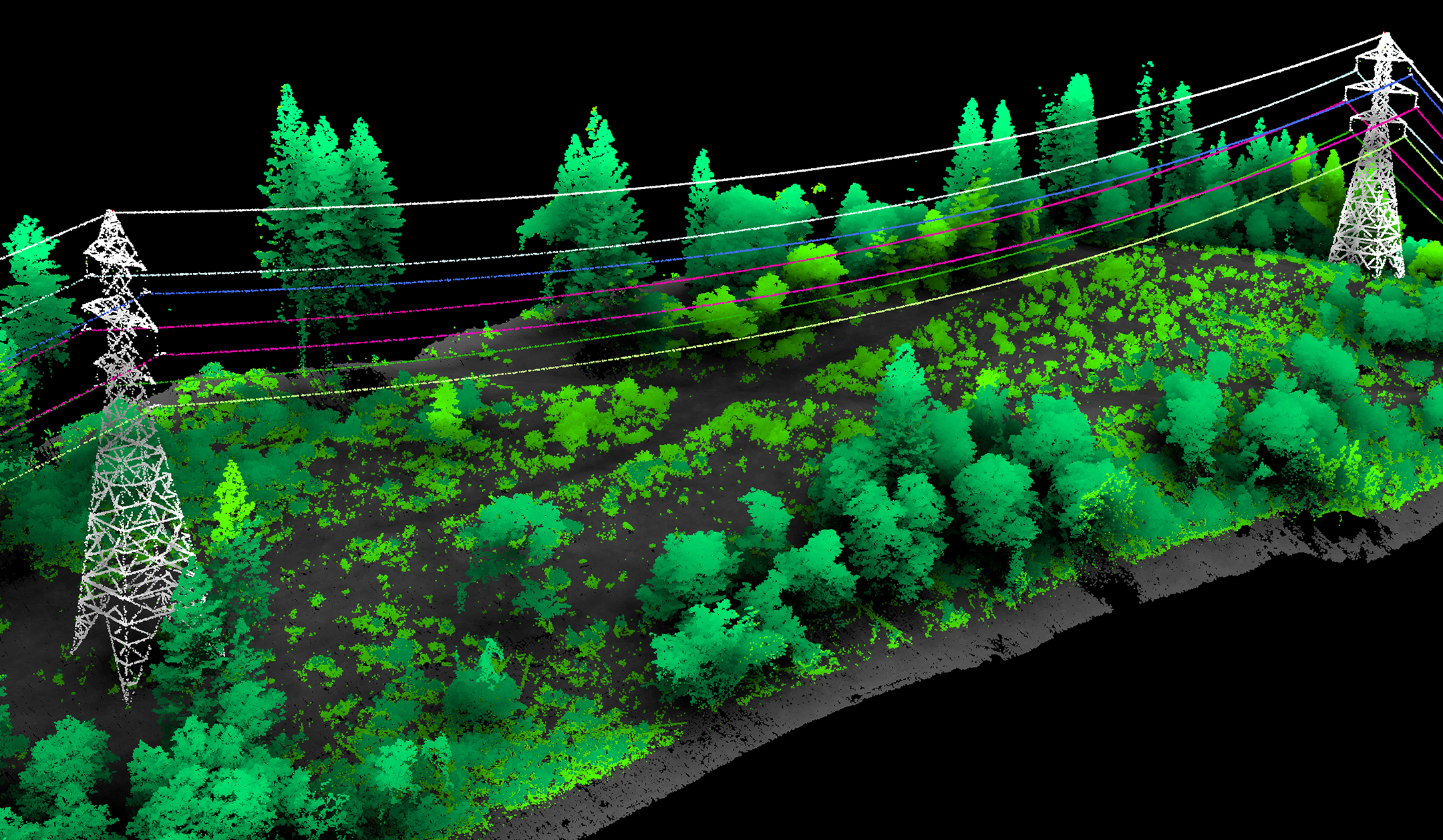
Denton’s session – Transmission – Evolving Operations – takes place on April 24 at 3:30 p.m. During it, he will outline how conventional cycle-based maintenance programs can fall short of adequately assessing vegetative risk, and explain how QSI is using high-resolution geospatial data and machine learning to identify and prioritize threats. He also will share real-world examples of how segmentation routines and electrical wire models were used in vegetation proximity analysis to produce quantitative geospatial maps used to support and inform condition based maintenance programs. The results of these projects suggest that LiDAR and hyperspectral data can be effectively combined to predict vegetative risk based on causal factors, including proximity to transmission infrastructure, genus and health.
For more information, contact Greg Denton at gdenton (at) quantumspatial (dot) com.
About Quantum Spatial, Inc.
Quantum Spatial, Inc., (QSI) provides geospatial intelligence to government and corporate organizations to mitigate risk, plan for growth, better manage resources and achieve advanced scientific understanding. A pioneer in advanced mapping technology, QSI’s end-to-end solutions deliver data and services of the highest quality and accuracy, leveraging the widest array of technologies in all types of landscapes. Clients use the company’s acquisition, processing, analytics and visualization solutions in a range of technical and scientific disciplines – from geology and biology, to hydrology, forestry and civil engineering. Utilities, oil and gas producers, engineering and construction firms, as well as the military and major government agencies, are QSI customers. QSI has multiple offices around the country. For more information visit quantumspatial.com, join us on LinkedIn or follow us on Twitter @QuantumSpatial.
Maria Bradley, Kickstart Consulting for Quantum Spatial, https://quantumspatial.com/, 415-509-0498, [email protected]
Share this article